Monday, October 29, 2012

Ocmulgee National Monument Background

This past Tuesday, 10/23/12, our Environmental Science class went to Ocmulgee National Mounds. We walked through the woods, examining trees and shrubbery as we walked. We went off the trail and examined a riverbed and its layering of soils. With a Munsell Soil Color book, classifying the the color of the soils of the riverbed. On the way back we stopped by the Great Temple Mound and went inside and listened to the history lesson. Once we exited, our weekly lab task was given to us. We are to dig deeper into the background of the historical land we were on. Below is the outside view of the Great Temple Mound, where ceremonial meetings were held.
This national park has evidence of 17000 years of continuous human habitation. This site was occupied during the Paleoindian, Archaic and Woodland phases. It once was home to the South Appalachian Mississippians, a group of Native Americans, in which they prospered. This land is located on the Macon Plateau at the Fall Line where the United States built Fort Benjamin Hawkins in 1806. This place was a site of trade and prospered due to its location. During the decline of the Mississippian culture, a group of people, named the Lamar, inhibited and thrived in the area. Structural sites and artifacts are found from this Lamar phase. During the year of 1540, Hernando de Soto's expedition led him through the area. While searching for precious metals his army wiped out most of the Native Americans and who survived had to combat Eurasian diseases believed to be brought by the pigs de Soto and his men brought with them. In the late 18th century, the Muscogee Indians inhabited the area. This was the last time of real independence for the Native American culture in this area. Many battles were fought for this territory that was eventually seized by the United States. 

**Images Courtesy of Google Images
**Information Courtesy of Wikipedia.org
Saturday, October 20, 2012

Not just dirt but SOIL!!!!

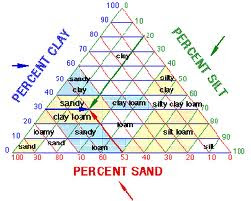
The following diagram is a soil diagram chart. This chart is used to determine the nature of the dirt. Dirt, as it is so elegantly referred to, is a composition of three components: clay, silt and sand. As shown by the diagram, given your percentages of the three components of your dirt sample, you can classify your sample. For percent clay, you read horizontally to your right. For percent silt, you read Southwest of your number. Finally, for your percentage of sand, you will read Northwest of your percentage. 
The following diagram is Munsell Soil Color chart. It is named after the Professor Albert H. Munsell and was adopted by USDA, United States Department of Agriculture. It bases its system on chroma, value and hue of a sample. Value represents the shade of white to black the color seems. Hue represents the general color, of the spectrum, the sample. Chroma is the shade and mixture level of the hue and value levels. 
This diagram below depicts the 12 soil orders of the world. The 12 soil orders of the world are alfisol, andisol, ardisol, entisol, gelisol, histisol, inceptisol, mollisol, oxisol, spodosol, ultisol and vertisol. The following chart is difficult to see, however, you can search the web for this poster or use a search engine to find out about any specific soil type. The predominant soil type for the state of Georgia is ultisol with large sites of alfisol and inceptisol.


*Pictures Courtesy of Google Images

Rocks, rocks, rocks and NO rocks

The above rock is obsidian. It is an igneous rock that is formed from the cooling of magma/lava. It is found where ever there has been rhyolitic volcanoes. You can find it in the Western United States, predominantly. Yellowstone National Park has a mountainside containing the rock. Its chemical composition is 70-75% SiO2 and contains MgO and Fe3O4. It is used for surgical scalpels due to its smoothness, however, it is not recognized by FDA for this purpose.
This rock happens to be slate, a metamorphic rock. It is formed from the combination of rocks being compressed with low heat and pressure. Large deposits, and the slate industry, are found in Spain, Wales and in the United States in Pennsylvania. It is composed of quartz and either muscovite or illite primarily. One can also find biotite, chlorite, hematite and pyrite as well. It is used in the construction business for roofing, flooring and for monument and head stone pieces.
The rock shown above is sandstone. It is a sedimentary rock formed by the layering of sediments being exposed to pressure from weight above pressing down. Sandstone is often found in deserts and dried-up bodies of water. Large deposits can be found in the Sahara Desert and the Arabian Desert. It is composed quartz and/or feldspar, mostly. This is because they are the most common minerals in the Earth's crust. This does not limit them to being the only type of sandstone though. 
This mineral is zoisite. It's chemical composition is Ca2Al3(SiO4)(Si2O7)O(OH). It can be found in metamorphic and pegmatitic rock. It is brittle, yet has a hardness greater than 6. It is found in Kenya, Norway, Pakistan and in the United States in Washington. It was formerly called saualpite.


*Pictures Courtesy of Google Images
*Information Courtesy of Wikipedia.org

Thursday, September 27, 2012

     This week in lab we walked all over campus and made our way to Tatnall Square Park looking at bushes, shrubbery, trees and flowers. This post will show and discuss three different trees, flowers and bush/shrubbery we encountered on our trip. In the trees section I will discuss Yoshino Cherry, Cabbage Palm and Magnolia trees. In the flowers section I will talk about Heather, Snapdragon and Marigolds. In the bush/shrubbery section I will review Sago Palm, Itea and Loropetalum.
                
Going from left to right, we have Prunus yedoensis (Yoshino Cherry), Sabal palmetto (Cabbage Palm) and Magnolia grandiflora (Magnolia). In Japanese culture, cherry trees symbolize the ephemeral nature of life. They have been historically observed and are celebrated for their beauty. A historical fun fact for the cabbage palm is in 1776 Charleston patriot William Moultrie built a fort out of palmetto trunks and defended it against the British military. They are also remarkably resistant to cold, fires, salt spray and flooding. The magnolia tree is named after French botanist Pierre Magnol. The flowers from the tree have been dated back almost 20 million years ago! The magnolia has plays, movies and novels named after them.
                    
Going from left to right, we have Calluna (Heather), Tagetes (Marigold) and Antirrhinum (Snapdragon). Heather grows in acidic soil and depending on the part of the world you live in, it is considered a food source or a weed. Marigolds are planted next to some crops as to deter animals and pests from eating the crops. They give off a pungent smell which wards off these animals and pests. Snapdragons are a toss up flower. Scientist have trouble with their taxonomy due to their genetics. They are also an example of incomplete dominance.
             
Going from left to right, we have Cycas revoluta (Sago Palm), Itea (Itea virginica) and Loropetalum chinense (Loropetalum). Sago Palm is very toxic to pets. The seeds of Sago Palm contain cycasin which is the most toxic. Itea is a plant commonly planted for its beautiful fall foliage. Loropetalum is a low maintenance shrubbery. It is known for its green, copper and red tones.


*Pictures Courtesey of Google Images
*Information Courtesey of Wikipedia
          On September 10, 2012, Dr. Rood took our class to the Ocmulgee River to do some basic testing. We were unable to measure elevation levels because we were missing a level. We did get to take clam counts and make a better educated guess to where they prefer to inhabit. We also did a water velocity test with an old soda bottle we found laying in the river bed. The above pictures shows the area we walked around, the approximate sites of the clam excavations and a similar path to which the soda bottle traveled for out velocity calculation. The above picture is not quite what the river looked like upon the day of our visit, in which the water was more shallow and revealed more islands.
           The water velocity calculation we used involving getting to two different locations, in the direction and opposite the direction of the flow, were we knew the distance from each other and then placing the bottle in the water and timing it from beginning to end. Once we had the time, we divided the distance by the time elapsed and came up with our water velocity for that segment of the waterway.
           The clam counts involved a filter type of device, let's call it a screen, that we would shovel sand into and then rinse until all the sand was pushed through the screen leaving behind the material that was too large to be pushed through the filter. Once the sand had been washed through, we took count of the clam shells that were remaining in the screen. We did this at three different locations and counted the largest clam population was where there was more water. Thus, leading one to assume, that clams prefer the water content to the sandy content.
            Unfortunately, we did not get to attempt the elevation determining section of the lab as we did not have a level for the string. My understanding of the experiment is that you have two poles, with lengths marked on them, connected by a string with a level on that string. You then would stick one pole in the ground and then carry the other pole along your line transect and stick it in the ground. You want a close to exact measure for how far you stuck each pole in the ground and make them even. You then make sure the level was reading even and observe the difference of measurement each stick was at the mark of string.
           The following insert is a Distance Vs. Elevation chart recreated from data given to me by Dr. Rood. This is what the data from the elevation transect would be used to create.

Monday, September 3, 2012

Here is a link to Hurricane Andrew that troubled Florida in 1992.
Isopleth maps are used to show areas that have similar qualities such as elevation, rainfall and other items. The map uses lines or color to distinguish the areas. Below is an example of such.